WALK
1:
EASBY
ABBEY AND rOUND hOWE
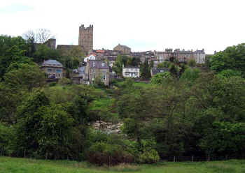
Richmond
town, with its spectacular Castle and cliff top setting above the Swale forms
the focal point of this walk, which includes some lovely riverside areas,
including National Trust’s woodland at Round Howe, and the glorious ruins of
Easby Abbey – perhaps getting there in the footsteps of the legendary Richmond
Drummer Boy.
Distance:
Distance from and back to the
market place is 6 miles – 9.5km
Time:
Allow 3 hours
Maps:
OS Explorer Map 304; most of the walk is also shown on the Richmond
- Britain’s Best Kept Secret leaflet
available from Richmond TIC.
Refreshments:
Huge choice in Richmond town centre
Toilets:
Richmond (by TIC), Round Howe Picnic Site (by footbridge)
Directions:
Start
the walk from the stone pillar or obelisk in the market place. Turn into
pedestrianised Finkle Street just behind the obelisk, (half left if you stand
with your back towards the Church). Turn left again at the end into Rosemary
Street and into and past the lovely Georgian houses of Newbiggin to Craven Gate. Turn right here, crossing busy Victoria Road with care, but keeping right
at the fork past West End Post Office along Westfields, climbing out of town
along what is now part of the Coast to Coast Path.
After a
little over a half mile (1 kilometre) you reach a track on the left, Green Lane.
This descends, with good views, past Low Leases Farm, eventually reaching to a
T-junction. Turn left to reach Reeth Road. Cross to where a wooden sign indicates the path through woods
down to Round Howe picnic site, with a picnic area and toilet ahead.
Cross
the footbridge over the river into the National Trust estate, turning left at
the other side. You can either follow the riverside path or keep right at the
fork across meadows and alongside the wood.
Both paths converge in Billy Bank Wood. Take the main path left,
downstream, which climbs through lovely woodlands, above a riverside cliff, to
emerge at Richmond Bridge.
Cross
the road, and turn right for a few metres to the entrance to the Football
Ground, where a Coast to Coast Footpath sign indicates the riverside path. There
are splendid views of the town and castle from here. Follow the path past
Richmond Falls to a stile leading into an area of scrubby woodland, climbing a
knoll, from where a well used path (not shown on the OS map) heads left down
towards Station Bridge. Continue on
the well constructed path through parkland, below the swimming pool and old
station, along the riverside, eventually joining the trackbed of the former and
much lamented Darlington-Richmond branch railway, closed in 1970.
Continue
along the railway to cross the old bridge below the weir. At a T-junction, turn
left towards Easby Abbey, the path emerging at the Easby Abbey car park
opposite St Agatha’s church. It is worth spending a few minutes to explore
this beautiful medieval church with its remarkable, if heavily restored, wall
paintings showing the Garden of Eden and the life of Christ.
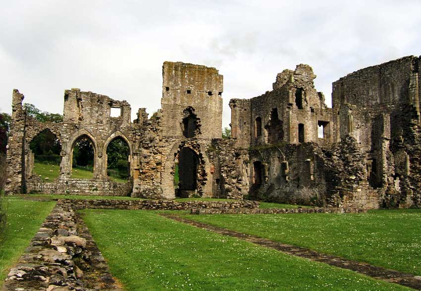
 From St
Agatha’s turn left along the access road to the Abbey itself, now owned and
managed by English Heritage (open daily - no charge). These magnificent Premonstratensian ruins in their beautiful
setting are remarkably extensive, dating from the 12th to the 15th
centuries, the most impressive building being the splendid Refectory, complete
with stone serving hatch and pulpit.
From St
Agatha’s turn left along the access road to the Abbey itself, now owned and
managed by English Heritage (open daily - no charge). These magnificent Premonstratensian ruins in their beautiful
setting are remarkably extensive, dating from the 12th to the 15th
centuries, the most impressive building being the splendid Refectory, complete
with stone serving hatch and pulpit.
From the
Abbey continue in the same direction to go past Abbey Mill, (private house) over
stiles, keeping to the top path above the river, again with fine views, past
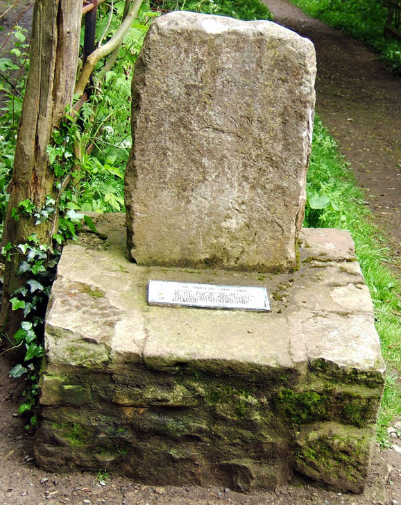
another recreation ground.  Towards the end of the path as it broadens to a track
you will pass an unusual memorial stone – to the legendary little Richmond
Drummer Boy who vanished when drumming his way along a secret underground
passage between Richmond Castle, the sound of his drum indicating the line of
the passage, but at this point, the story goes, the drumming ceased and the lad
and the secret passageway were never found again.
Towards the end of the path as it broadens to a track
you will pass an unusual memorial stone – to the legendary little Richmond
Drummer Boy who vanished when drumming his way along a secret underground
passage between Richmond Castle, the sound of his drum indicating the line of
the passage, but at this point, the story goes, the drumming ceased and the lad
and the secret passageway were never found again.
Where
the track becomes a broad drive between two houses, look for a narrow, shady
track, left which descends to the river. Take
the partly concealed stony way, right, which follows the edge of the river to
and under Station Bridge where it joins a much more obvious path through the
riverside park, below the stone wall of the school grounds.
Keep the wall on the right to where it joins and enclosed way and steps
on the right which climb between buildings into Frenchgate.
Turn
left here, but instead of going into the Market Place on the right, keep ahead
along Millgate. As this narrow old lane begins to descend, a ramped way on your
right indicates the start of Castle Walk – a superb, level walkway and series
of viewpoints under the Castle Walls. Follow
the Way round until it emerges near the top of the Market Place.
© Colin
Speakman, May 2005
Back
to Walk Introduction
 From St
Agatha’s turn left along the access road to the Abbey itself, now owned and
managed by English Heritage (open daily - no charge). These magnificent Premonstratensian ruins in their beautiful
setting are remarkably extensive, dating from the 12th to the 15th
centuries, the most impressive building being the splendid Refectory, complete
with stone serving hatch and pulpit.
From St
Agatha’s turn left along the access road to the Abbey itself, now owned and
managed by English Heritage (open daily - no charge). These magnificent Premonstratensian ruins in their beautiful
setting are remarkably extensive, dating from the 12th to the 15th
centuries, the most impressive building being the splendid Refectory, complete
with stone serving hatch and pulpit.