Walk
4 MARRICK PRIORY AND WILLANCE’S
LEAP - REETH TO RICHMOND
This walk proves that the
lower part of Swaledale is no less spectacular that the upper part of the valley
in terms of open views and dramatic landscape features, though more thickly
wooded. The route utilises meandering field paths across meadows (please walk
single file) but also ancient tracks such as the medieval Nuns’ steps from
Marrick Priory, culminating in a spectacular climax along the length of
Whitcliffe Scar into Richmond. Wainwright’s popular Coast to Coast Path is
followed for part of the way, but with some different sections to avoid tarmac
and to enjoy even better views. It is also a moderately strenuous walk,
undulating throughout, with at least three fairly steep climbs and with a
significant distance to cover, but if you are staying in Richmond without
needing to catch return transport that may be less of a problem.
However it can be shortened by catching a return bus from Downholme
Bridge, 1.6km or one mile south of Marrick by field path and lane, from where
the route could start. This cuts the distance by approximately half.
Distance:
12½ miles – 19 kilometres
Time:
Allow 6-6½ hours
Maps:
OS Explorer Maps OL30, 304 or Harvey Dales North (part).
Refreshments:
Café, pubs in Reeth, nothing in Marske or Marrick; however light refreshment
available in the summer months at Nun Cote Nook Farm, 200 metres of the route
north of Marrick, plus drinks at Hardstiles Top farm near Marrick
Toilets:
Reeth, Round Howe picnic site.
Getting
there:
Take the bus from Richmond Market Place to Reeth (also calls at Downholme Bridge) which leaves at 0900 and 1205 on Mondays to Saturdays (service 30) and at 1030 on Summer Sundays & Bank Holidays (service 830).
Travel time to Reeth 24
minutes.
Coming
back:
Buses leave Downholme Bridge (on main A6108 roadside by junction) for Richmond at 1215, 1302, 1350, 1515 and 1642 on Mondays to Saturdays (service 159) and at 1530 and 1738 on Summer Sundays & Bank Holidays (services 859 and 830).
Emergency
taxi back-up: Phone 01748 825 112 or
01748 822 269
Directions:
From Reeth Green head for
the old stone pump at the top end of the Green, following the road to the right
between cottages, going right again down to the Arkle Guest House, and right
alongside the little Arkle Beck into what seems to be a riverside garden, but is
also the start of the beckside walk behind the village which emerges underneath
and to the far side Reeth Bridge.
Cross the bridge and at
the first corner take the most southerly of two paths which heads due east over
stiles to High Fremington. Follow
the lane through the village where slightly to the left the path continues in
front of cottages, crossing fields generally by stiles with small pedestrian
gates to meet the Marske road west of Fremington. Turn right down to the road
junction, and left along the narrow tarmac lane towards Marrick Priory.
To avoid a mile of tarmac,
take the step stile reached 50 metres on the left, which leads to a lovely field
path, roughly parallel to the road but with better views, climbing slightly left
towards the wire fence above left, where, about half way along and above the
field corner a stile can be found. The path is more or less in a straight line
from here, mainly marked by stiles, and a faintly visible across the meadows as
the tower of Marrick Priory comes into view.
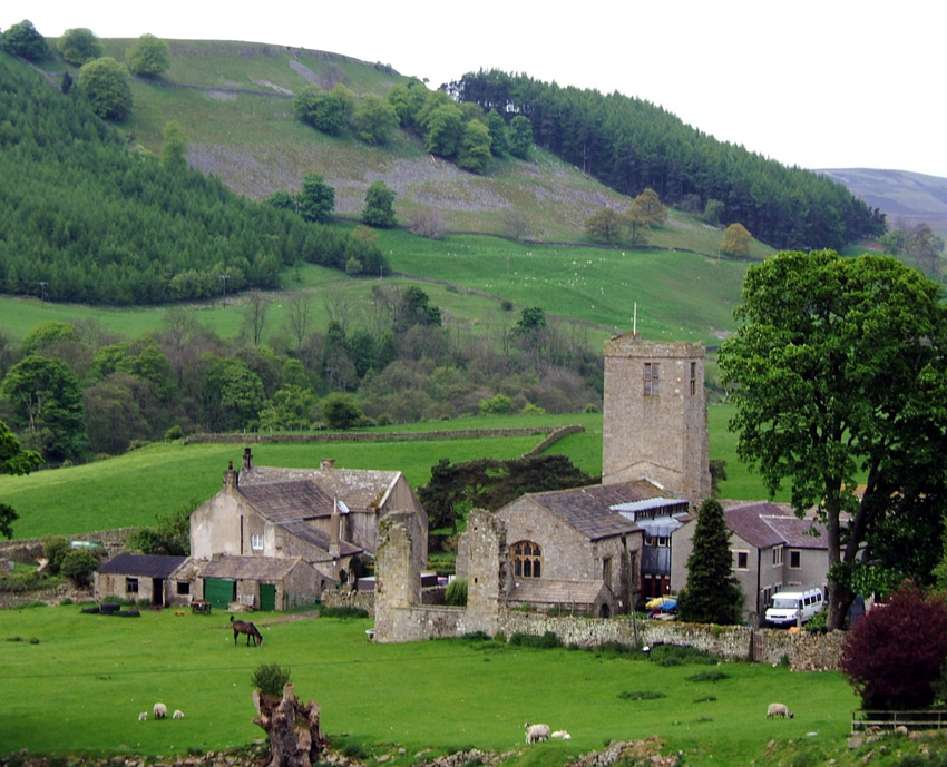
The path joins the lane at
the farm just below the Priory. Marrick Priory, the subject of a famous
Swaledale painting and engraving by JMW Turner, is a former Benedictine Nunnery
founded in the 12th century, and is now converted into a residential
youth centre.
A short distance east of
the Priory a path crosses to Steps Wood – this is the celebrated Nuns’
Causey, a beautiful flagged medieval causeway which climbs steeply through Steps
Wood, flanked by wild flowers, eventually following the wall by pastures and
entering Marrick village.
The obvious direct track
out of the east of the village is not a right of way and walkers following the
Coast to Coast path must loop to the south along the lane around past the old
school house to pick up the path to Hollin Farm across several small enclosures,
over stiles, before entering open
pasture, the steady use by Coast to Coast walkers making this an easy path to
follow in what would be otherwise tricky terrain, soon crossing the track to Nun
Cote Nook (refreshments) before descending North Gill past Ellers, good
waymarking and the path on the ground clearly indicating the way uphill to
Hollins Farm. The route is to the west of the farm, with a stile in the corner
of the wood reached by turning half right once beyond the farm track. The next
stile is in the top left hand corner of a long field, bearing right, over a
second stile and diagonally over the next field down to Hardstiles Top.
To cut out road walking,
leave the CtoC, going left along the lane for 120 metres to a gate where a path,
heads due northwards down the field to another stile in the corner, then
directly downhill heading for a small house in Skelton Lane below. To the left
of this house is a stile (signed) leading to the path down to Pillmire Bridge, a
lovely old stone bridge – note the old wooden waterwheel still in situ close
by. Follow the path along Marske
Beck, which emerges at steps by Marske Bridge. Turn left into the village.
You are back on the Coast
to Coast. Follow the lane for some
400 metres to where, after it begins to descend, a stile and signpost indicates
the path crossing more fields, before descending to a stream and footbridge in a
side valley, and a steep climb up the hillside towards Applegarth ahead – a
white cairn indicting your destination
The cairn is on a level
track, which offers temporary respite as you head towards West Applegarth Farm,
again with fine views along the dale. About 50 metres beyond West Applegarth,
opposite a ruined barn, look for a blue metal gate on the left which is the
start of a path, which bears right, above a fence, then left again across Salmon
Gill, climbing through scrubby woodland over the shoulder of the hill before
descending to join the tarmac farm road through Deepdale.
Climb steadily up this steep, narrow pass; at the road summit just before
the junction with the Marske road, turn sharp right before the telephone mast on
a rocky bluff. This joins the path along and around Whitcliffe Scar, a
magnificent, continuous panoramic viewpoint looking across a thickly wooded
landscape, culminating at Willance’s leap, 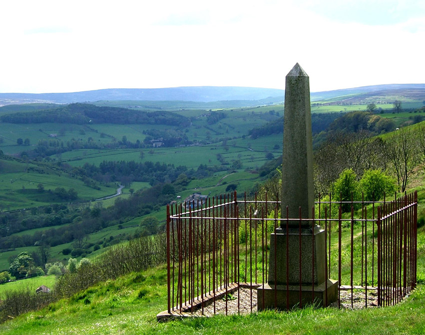 the curious twin memorials
commemorating an event in 1606 when Robert Willance, a wealthy Richmond
draper’s son out hunting on a winter’s day, was lost in a thick fog, and
mistakenly galloped his horse to and over the edge of the cliff.
The horse, terrified, took three great leaps into the abyss, falling two
hundred feet, killing itself but leaving the rider miraculously with only a
broken leg
the curious twin memorials
commemorating an event in 1606 when Robert Willance, a wealthy Richmond
draper’s son out hunting on a winter’s day, was lost in a thick fog, and
mistakenly galloped his horse to and over the edge of the cliff.
The horse, terrified, took three great leaps into the abyss, falling two
hundred feet, killing itself but leaving the rider miraculously with only a
broken leg
It is a superb viewpoint
and suitable climax to the walk. The
route follows the cliff edge. Keep
ahead over stiles and where the path opens out into pasture, keep to the left of
gorse buses ahead, but where a crossing wall comes into view, the path turns
sharp right downhill heading towards High Leases Farm.
Turn left at the farm, past Whitecliffe Farm, just beyond which at the
Richmond signs, there is a seat and quotation from Wainwright himself extolling
the fine view across Richmond town.
Keep straight ahead on the
lane which goes through Westfield and emerges onto Reeth Road by West End post
office. Cross Victoria Road at the
junction with care and walk along Cravengate ahead, before taking the first
turning left along quiet Newbiggin, turning right into Finkle Street to the
Market Place.
© Colin Speakman, May 2005